Project News


Here you will find updates on the scheme’s progress and details of any upcoming works to be carried out by the team.
RIFAS intrusive ground investigations (January 2024) SHOW
As with the non-intrusive surveys, the majority of works will be carried out on private land, however there will be a requirement to carry out surveys in the public highway and Crosshouse car park. These works will help us to better understand the ground conditions in the local area and will enable us to further develop our proposals for the scheme.
What did the non-intrusive surveys show you?
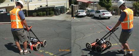
In Autumn 2023, we undertook several non-intrusive Ground Penetrating Radar (GPR) surveys. These surveys used radar signals to detect anomalies underground including services and structures.
After reviewing the results of these GPR surveys we were able to identify more precise locations within the GPR survey areas where we would be able to undertake the intrusive surveys, whilst avoiding any such services or structures.

What will the intrusive surveys involve?
The intrusive surveys will involve use of cone penetration tests (CPTs) and cable percussion boring.
Prior to CPTs or boreholes being undertaken, we will first hand dig inspection pits to locate any buried services and verify the findings of the non-intrusive survey works.
CPTs involve pushing a cone between 15-20 metres into the ground and measuring resistance to the cone. This will provide information on the soil and material below ground.
Boreholes of between 15-25 metres will be advanced using a cable percussion rig. Samples from these boreholes will be tested in a lab for their engineering properties and environmental purposes.
These surveys will enable us to gain the best possible information on local ground conditions, which in turn will influence the design of the flood defence.
Where will the intrusive surveys be taking place?
The intrusive ground investigation surveys will be undertaken on the same sites that the non-intrusive surveys were. As before, this means they will mainly be undertaken on private land along the scheme frontage. We have contacted all landowners and leaseholders that will be directly affected.
There will also be surveys undertaken at Crosshouse car park, and access to areas of the car park and slipways may be impacted for a short period.
Works compound location
To manage the works on a day-to-day basis we will have a compound set up at Crosshouse car park. This will mean there are fewer parking spaces at this location, but the car park will still be open.
Who will carry out the surveys?
The works will be managed by VolkerStevin, supervising a subcontractor, Socotec.
When will the surveys be taking place?
The ground investigations themselves will be taking place from Monday 8 January 2024 and are due to be complete by the end of April 2024. Regular monitoring of water samples across a selection of the borehole sites will then be required to be taken up until the end of May 2024.
Additional intrusive investigations may be required as the project progresses and more information will be made available on these in due course.
How will this impact me?
The majority of intrusive surveys are being carried out on private land and therefore it is anticipated there will be minimal disruption to the general public.
In addition to those required across January and March, some lane restrictions will be in place along Belvidere Road and Marine Parade in mid-April. This will require some night time work across a couple of evenings, however any disruption will be kept to a minimum. We would like to take this opportunity to apologise in advance for any inconvenience this work may cause.
While the surveys are being carried out, it is anticipated that survey areas will be cordoned off, preventing access to anyone other than the Ground Investigation team. Prior to the start of the works, we may reserve the works area using ‘no-waiting’ cones; please do not park where you see these cones as we may need to remove vehicles which block access to our works.
Further Information
If you would like further information on the surveys or believe that you may be affected by the surveys but have yet to receive correspondence from the Project Team, please contact us at rifas@southampton.gov.uk.
Non-intrusive ground investigation surveys (October 2023) SHOW
As part of the scheme development, the project’s design contractors, VolkerStevin, are to carry out non-intrusive (above ground) site surveys in October 2023. The majority of works will be carried out on private land, however there will be a requirement to carry out surveys in the public highway and Crosshouse car park.
What are you doing?
To help with development of the scheme design we need to undertake non-intrusive ground investigations to better understand ground conditions and utilities. The surveys will be carried out using a Ground Penetrating Radar.
What is a Ground Penetrating Radar?

A Ground Penetrating Radar survey uses radar signals to detect anomalies underground. The survey is primarily used to detect underground services and structures.
Where will the surveys be taking place?
The surveys will be mainly undertaken on private land along the scheme frontage. Contact has been made with all landowners and leaseholders that will be directly affected.
Surveys will be undertaken in the public highway along Belvidere Road and Marine Parade. The works will take place overnight, beginning Wednesday 18 October, for approximately two weeks. Lane restrictions and closures will be in place between 8pm and 6am. All residents and businesses likely to be impacted will be contacted by Balfour Beatty by letter and information will be available on SCC Social Media channels.
There will also be surveys undertaken at Crosshouse car park and access to areas of the car park and slipways may be impacted for a short period.
All works will be undertaken on the quayside and no works will be undertaken within the Itchen estuary.
Who will carry out the surveys?
The works will be managed by VolkerStevin, supervising a subcontractor Socotec.
When will the surveys be taking place?
The investigations will be taking place from Monday 9 October 2023. Further intrusive investigations will be required and more information will be made available shortly.
How will this impact me?
The majority of surveys are being carried out on private land and therefore it is anticipated there will be minimal disruption to the general public.
Works carried out in the public highway will be taking place overnight (8pm to 6am) to minimise disruption and we are not intending any work to be carried out at weekends. Properties close to the carriageway may experience a temporary disturbance such as flashing lights and reversing sirens as this can be a noisy process. We would like to take this opportunity to apologise in advance for any inconvenience or disruption this work may cause.
While the surveys are being carried out, it is anticipated that survey areas will be cordoned off, preventing access to anyone other than the Ground Investigation team.
Further Information
If you would like further information on the surveys or believe that you may be affected by the surveys but have yet to receive correspondence from the Project Team, please contact us at rifas@southampton.gov.uk.
Green light to commence the detailed design phase (August 2022) SHOW
Over the past year, the Project Team has been developing the RIFAS Outline Business Case, which outlines the need for the scheme, and the options appraisal (an analysis which includes cost, benefits and risks). The team is therefore now able to recommend a preferred option to take forward to detailed design stage.
The scheme received assurance for its Outline Business Case in August from the Environment Agency’s Large Projects Review Group. This group provides assurance and confidence that the team is developing a viable scheme that will achieve the planned benefits. The group also approved financial sign-off of £7 million for the next three-year period (detailed design phase). The detailed design phase incorporates all activities needed prior to construction.
The Outline Business Case is the culmination of three years hard work by the Project Team and collaboration with a variety of stakeholders. We’d like to take this opportunity to thank all those that have contributed to the scheme, and we look forward to continuing to work with you and others as the scheme progresses.
There is still a funding shortfall that we are working to bridge. Southampton City Council has committed a significant contribution to the scheme and the team is bringing onboard investment specialists to help identify and secure the required investment, as well as looking for opportunities to reduce costs through value engineering.
If you’d like to keep up to date with Project News, sign up to our mailing list which can be found under ‘local information’.
The RIFAS Newsletter (Autumn 2021) SHOW
The Autumn 2021 RIFAS newsletter is available. If you would like to receive this newsletter in another format, or you would like to sign up for email updates, please contact us at rifas@southampton.gov.uk.
Proposals approved by Council (November 2021) SHOW
Southampton City Council has approved a series of recommendations regarding the River Itchen Flood Alleviation Scheme (RIFAS) to reduce the risk of flooding on the west bank of the River Itchen.
At a Full Council meeting on 17 November 2021, councillors agreed to the recommendations that outlined a mix of setback (behind existing buildings) and frontline (next to the water’s edge) flood risk infrastructure.
The scheme will be mainly funded by the Environment Agency, however Councillors also approved the proposal to contribute £10.2m towards the scheme to bridge the funding gap and to replace the quay wall at Drivers Wharf. The £10.2m will mostly be made up of Community Infrastructure Levy (CIL) payments, which are funds collected from developers when there is a need to build additional infrastructure as a result of the development.
The approval means the project team can progress the outline scheme design which will be subject to planning permission in due course.
Options Development Engagement (Commencing 7 May 2021) SHOW
The Project Team have been appraising potential design options which have included replacing or adapting the current quayside infrastructure and building a defence set back away from the quay edge. We would like to discuss the design options with all businesses across our scheme area which will help inform a decision on a leading option.
What are you doing?
Over the next couple of months we will be contacting all stakeholders that own a freehold or leasehold that may be impacted by and have an influence over the design. We hope to hold virtual meetings to discuss the design and specific alignment of the options.
Why are you engaging?
The Project Team would like to discuss the options with all businesses that may be impacted. Through our engagement we are looking to understand all the potential impacts to each and every business which we can then look to minimise through both the design and construction process.
When are you starting engagement?
Over the next couple of weeks members of the Project Team will start contacting and arranging virtual meetings with all identified stakeholders. We will begin holding virtual meetings from 7 May.
If you believe that you may be affected by the scheme but have yet to receive correspondence from the Project Team, please contact us at rifas@southampton.gov.uk
Ground Investigation Surveys (Commencing 12 January 2021) SHOW
As part of the scheme’s initial works, the project’s design consultants, JBA Consulting, are to carry out site surveys along the scheme frontage from 29 June 2020.
The Project Team have developed Frequently Asked Questions for the ground investigation works. If you have any questions that are not covered on this page please contact us at rifas@southampton.gov.uk.
What are you doing?
To help with development of feasible flood risk management solutions we need to undertake GI in order to understand the ground conditions on site. The surveys will be carried out using Ground Penetrating Radar and utilities detection surveys (Phase 1) as well as main Ground Investigation intrusive works (Phase 2).
What are Ground Penetrating Radar and utilities detection surveys?
 A utilities detection survey is used to identify services underground. One way to do this is through a Ground Penetrating Radar survey which uses radar signals to detects anomalies underground. It is non-intrusive and is our best opportunity at avoiding service disruption.
What are Ground Investigation intrusive works?
 The method of collecting data will be Cone Penetration Tests (CPTs). These involve pushing a cone into the ground and measuring resistance to the cone, providing information on the soil and material below ground. A drilling rig will be on standby to deal with any obstructions in the ground.
Where will the surveys be taking place?
All GI surveys will be undertaken on private land along the scheme frontage. The works will be on the quayside and no works will be undertaken within the watercourse. Contact has been made with all landowners and leaseholders that will be affected by the GI surveys.
Who will carry out the surveys?
The works will be managed by VolkerStevin, supervising a subcontractor.
When will the surveys be taking place?
The investigations will be taking place from Mid-January. Further investigations may be required as the scheme develops.
How will this impact me?
All the surveys are being carried out on private land and during the surveys there will be no disruption to Public Right of Way. While the surveys are being carried out, it is anticipated that the areas will be cordoned off, preventing access to anyone other than the Ground Investigation team.
If you believe that you may be affected by the surveys but have yet to receive correspondence from the Project Team, please contact us at rifas@southampton.gov.uk.
Surveys (Commencing 29 June 2020) SHOW
As part of the scheme’s initial works, the project’s design consultants, JBA Consulting, are to carry out site surveys along the scheme frontage from the 29 June 2020.
A number of surveys will be carried out as part of these initial works to inform the design of the flood infrastructure and help understand the environmental impacts of the scheme.
A summary of the surveys being completed and durations of these can be found in the table below.
River Itchen Flood Alleviation Scheme Surveys
| Survey | Duration | Description |
|---|---|---|
| Bathymetric | Two weeks | A boat will be launched from a public or private slipway to record the below water riverbed levels. |
| Drone | Two days | A multi-rotor drone will be flown at 110m above ground level to record the ground elevation across the whole of the scheme area. |
| Terrestrial topographic | Six-eight weeks | A traditional topographic survey (land survey) will be conducted to create a detailed and accurate plan of both natural and man-made features and obstructions across the scheme area. |
| Condition assessment | Two weeks | A boat will be launched from a public or private slipway to inspect the condition of the existing flood risk management infrastructure along the frontage, record any defects and estimate the residual life. |
In undertaking this work we would like to reassure you that the Environment Agency, Southampton City Council, and the project appointed consultants and contractors will follow the good practice and 'Site Operating Procedures', as developed by the Government Construction Board working with the Construction Leadership Council, to ensure our work is completed safely.
Who will be affected?
The Project Team have contacted all of the landowners and leaseholders that are along the scheme’s frontage and who may be affected by the upcoming surveys.
If you believe that you may be affected by the surveys but have yet to receive correspondence from the Project Team, please contact us at rifas@southampton.gov.uk.

