River Itchen Flood Alleviation Scheme


Southampton City Council (SCC) and the Environment Agency are working in partnership to design and build the River Itchen Flood Alleviation Scheme (RIFAS). The scheme aims to reduce the risk of tidal flooding to the west bank of the River Itchen, including to areas of Northam, St Marys and Chapel.
Where is the scheme?
The proposed scheme frontage extends from Mount Pleasant Industrial Estate in the north, to the Southampton Water Activities Centre, just south of the Itchen Bridge. Presently there are no formal flood risk structures to protect the city from tidal flooding in this area, and where flood infrastructure does exist, it is in private ownership, offers various degrees of protection and is at varying conditions. Therefore existing quay walls, structures and land heights are not high enough to provide the level of protection needed from more frequent and severe flooding events expected in the future with climate change.
View a map of the scheme extent.
The map shows the River Itchen to scale. The start point being close to the Itchen Bridge stretching to Bevois Valley.
Why the scheme is needed
- Currently over 150 homes and over 200 businesses are at risk from tidal flooding.
- The provision of new flood risk management infrastructure will reduce tidal flood risk for over 1100 homes and 900 businesses by 2115.
- Key infrastructure, including electricity sub-stations, roads, rail and listed buildings are at risk from tidal inundation.
- Flooding of businesses and public footways has occurred along the proposed scheme frontage on a number of occasions over the past 20 years. High magnitude events have caused damage and disruption to local businesses, including significant flooding events occurring in 2014, 2008 and 2005.
Where we are now
At the beginning of 2019 the Environment Agency and Southampton City Council agreed a partnership to relaunch the RIFAS. We are currently in the outline design stage of the scheme, developing our design options to deliver a feasible flood alleviation project.

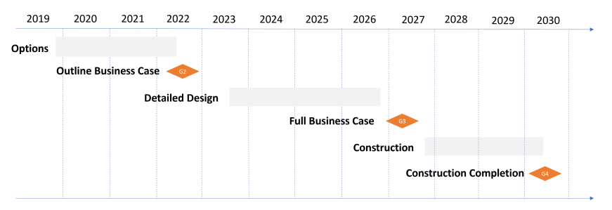
The timeline shows the board milestones for the scheme. Option planning until early 2022, Outline Business Case July 2022, detailed design 2023-2027, Full Business Case April 2027, followed by construction 2027-2030.
The options stage of the programme involves coming up with a number of feasible options that work for the area and meet our criteria including engineering suitability, cost, benefit and environmental impact. Work within this stage results in an ‘Outline Business Case’, a report which shows all the workings and justifications towards each of the potential options, and evidence for the preferred one. The report is submitted to the Environment Agency for approval at Gateway 2 (G2).
Contact details
Please see our frequently asked questions for more information and answers to any questions you may have.
For any further details or enquires about the RIFAS please contact a member of the project team via our RIFAS email.
Email: rifas@southampton.gov.uk
| Document | Type | Size |
|---|---|---|
| Scheme Extent Map | 61.0 KB |


